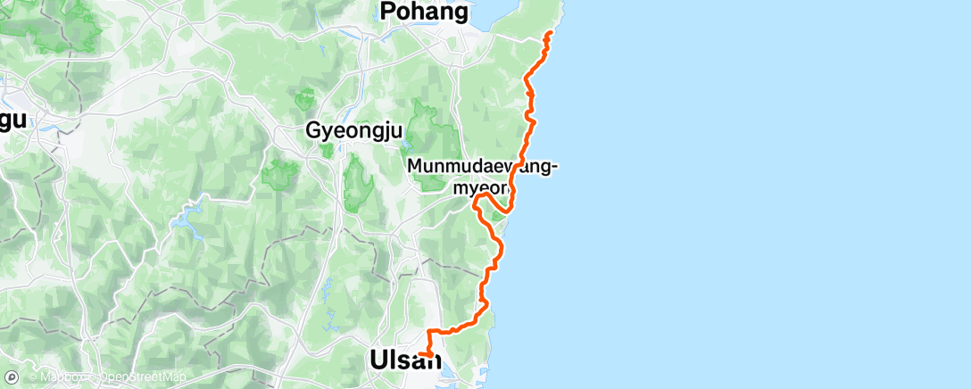
Km cycled: 92.5km, elevation gain: 780m
Stayed: Motel Carpe Diem (I know, I know), Guryongpo
The day started a little later than expected (that comfortable bed!) and I realised the load on my bike was going to keep my speed down. Oh well. The immediate journey out of Ulsan was pretty nice – up to Taehwagang along quiet roads (perhaps a Covid reflection, but pavements were available) and then along a nice riverside dedicated path. This is what I imagined most of the route would be like. I know. Shoot me.
Over the Myeongchon Bridge and back under to the water, and I found the first East Coast Bike Path sign. At this point, these aren’t super reliable. Following the water West then North past the Costco was all very pleasant. Turning East was the first indication I wasn’t in Kansas (or the Seoul-Chuncheon delight) any more. Dedicated by-stream paths became narrow pavements on hills with a lot of traffic lights. Boring (and slow). Good convenience stores along this stretch though.
This doesn’t last too long (though it FELT a lot longer) before the shared pavement abruptly ends and there is a nice dedicated crossing to… well nowhere really, except the lobby of a restaurant. In any case, the route takes you up what I was to learn later was the Muryong Pass. Going up was a long, uninteresting slog – not all that steep (165m gain over 2.7km) at least. There’s a rest area on the way up, that I expect will later have a phone box stamp station in due course. Then a short plateau and a similar downhill run – this time with a painted bike lane on both sides. After a while there’s a small stream to follow, all the way to the coast. Hooray! Some nice riding mixed with roads by seafront car parks. Good places to buy seafood, too, and another rest centre with a sign. The towns were quiet, the cycling flat and easy. Signage could have been better, though – this was my first stupid wrong turn of the trip, going straight on (guided by signs and road markings saying to go straight on) when the route turned right over a bridge. Still, there was a nice wee stepped waterfall to see. And an angry yappy dog.
Onto a larger road with cycle lane on the pavement and the usual down-up-down-up of the kerbs. A few parked cars at junctions to weave around, but nicer than the Seoul equivalents. Lots of parked cars on the road too – but for ultimate posterior comfort, if it’s quiet the road would be better than the bike path. (This is a somewhat common theme on this route, I was to realise.)
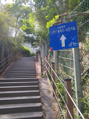
Out of the town, into the country. The main road joins a highway, we get to ride closer to the coast – mostly shared roads now, beach to the side. The blue cycle paths signs continue to pop up, mostly offering reassurance of going the right way rather than navigational assistance, but you’d take it. The thin blue line by the side of the road, similarly. Villages, pensions and fishing boats. Suddenly a sharp left – to what? Yes, it’s the first cycle route I’ve been on to feature stairs. 걸어가시오 demands the sign in red. Frankly if anyone has cycled up this, they deserve a podium place. Kakao Maps doesn’t get this right, by the way, but Naver does. Gotta use both.
Still, up we go. Now a dedicated cycle lane by the highway. Not for long, though, as the path takes us onto a slip road, down a hill, back up the hill, a few choice words along the way for whichever cucking funts made this particular choice. Now a small road with studs and a line to guide you to cycle in the dross by the kerb. Northbound looked nicer, I won’t lie – you grin smugly as you see the car lane brazenly cross the southbound cycle lane, only to let out another of those choice words as the northbound lane ends abruptly and throws you back into the road. Still, they’ve put up a red and yellow “자전거 주의” sign, so cars can prepare for exactly how to run you over. Cheers lads. At some point the lane reappears, then becomes a two-way cycle lane next to the road (rather than a lane on each side). And back to the water and road cycling. Another likely rest area. And on, and on. It’s not a bad ride, really, but not that memorable. Then a dedicated path for a bit, by the sea. Not for long, of course, but a nice respite. Then the route takes you away from what looks like a lovely path, left up a small hill and back to the road. Why are you doing this, cycle path, why? The road itself isn’t nice, with a cluster of motels and very little protection from the speeding bongo trucks as you slog on upwards. Some gas stations (not good places to buy drinks in this country), coffee shops (not cheap places to buy drinks in this country) complete what is a bit of a miserable stretch. Before long though the road is taking you down into another town and back to the small road, seafront riding. Nice parts, too! Some of the nicest riding of the day in fact. Until you get to the bloody nuclear power station.
Don’t get me wrong, I like electricity. But this is where you basically give up on the sea for a 15km trip through the countryside (the first 7km of which uphill, mostly gently, gaining 105m). Tarmac roads, pretty narrow for the first parts. It’s boring. It’s frustrating. It’s, ok, a bit pretty in some places (especially at 상라교 and the Gameunsaji Temple Site). There’s pretty much nowhere to buy water this entire stretch. Interestingly, going northbound for the “top” of this detour (actually east at this point but you know what I mean) was a whole separate lane that cyclists pretty much had to ourselves. Going the other way, you’re in the road. Eh. Since you’re on National Route 14 at this point, this might be a difference you care about. Anyway that goes away, but quickly there’s a crossroads with lights, where you have to go straight on over – much to the confusion of the drivers around you (you are crossing where the 14 meets Prefectural Route 929, and taking neither), BUT the sea is (kind of) in view! You’re now on a weird parallel route to the big 929 road. Pass a few bus stops that look rather inconvenient for the distant houses they presumably serve. The Temple Site is down here too.
The northbound and southbound route split at the end of this – northbound is a tunnel under the main road, and then yes – really – up the slip road (not the small farm track next to it) and onto the highway. Not for long though: the highway heads right across a bridge, and there’s a crossing (no lights) and another (with them) to get to the smaller road straight ahead where the bike route continues. Before long what looks like a dedicated cycle path appears (it’s not, it just points the way) and takes you sharply downhill, and back to a road-by-the-water-that-becomes-a-trip-through-a-village. The blue roadside line is essential here. One steep hill back to the road, but a nice dedicated cycle path then runs just long enough to ride you into the back of a parked car. Well, live with it. A bit more dedicated cycle path, back onto the road (though there’s more studs’n’paint in the opposite direction), and back following the road with another half-arsed attempt at pretending there’s a cycle lane, followed by yet more studs’n’paint. This is National Route 31, for what it’s worth, so it ain’t quiet. And you just kinda keep on this, thinking “what the fuck am I doing?”, but at least there’s a fuck-off massive Buddha to ride past. On Kakao Maps it is on the roof of the building, but when I passed it was on the pavement. Maybe he jumped off after seeing the pain of cycling this part of the route. Who knows.
Just before the last stretch on this road there’s an uphill section with a separated cycle lane along a boardwalk. Worth taking. The opposite direction looked sketchy as hell, to be honest, but no point being smug. It was a blessed relief to get off that road and onto another small coastal road, but then it is just a game of being off the main road, on the main road, etc., etc., rinse and repeat. The main road changes from National Route 31 to National Route 4 at some point, but you won’t care. Then the route veers off to the right (right after a “go straight on” blue cycle route sign, cheers for that eh) and it’s back to that “road through the village” cycling. There were times where you’re on a road that’s not the road by the sea – fair enough avoiding some hills and a bit more direct, but whether the route takes this choice or not seems entirely random. You’re not, at least, on major roads for most of this. Phew.
You rejoin 31 at the Zaza Motel. There’s a windmill opposite marking a camping and caravan site. Some of the up-hills had those half-arsed cycle lanes painted on the side of the road where drivers like to idle. Again some stretches of separated cycle lane northbound (only). You’re a little above sea level now, so some nice views but more up-and-down, more slog. Frankly I suspect when they make this part of the route official, they’ll move the cycle route away from 31 – depends how they feel about making you wade though. I guess that’s why they didn’t make the route follow 동해안로2714번길 (yet?). It looks like a bridge over the tidal water on the map, but it decidedly isn’t. Anyway. Sloggity sloggity slog slog, not feeling quite as exposed as previously but still often dull. A few stretches get you back to the water at least. Suck it up, until the “Pohang 35km” sign. If you are following the East Coast route, note carefully: THIS IS A LIE. Also, soon after this there is a sharp right turn with the sign hidden halfway up a telegraph pole behind a tree. Reader, I did not see it and bumbled uphill on the highway far too long before the expletives returned. Anyway at least fixing the mistake was downhill.
This is where I first saw the road markings for the path: “동해안 자전거길”. Unfortunately it is written vertically in two columns, and I had no idea what “동자 해전 안거 길” was on about. Worked it out (a lot) later. This is also about where the blue signs become a lot more scarce, as does the blue paint. So worth knowing. I actually really liked this bit – road number 3936. Then back to 31, same old. Worth saying that at the Sea Palace Penion turnoff, there’s a very nice looking shared cycle path/footpath off to the west, that I think could take you straight to Pohang and miss out the peninsula to come. But we’re not here for that, so onward! Soon back off 31 and by the water for a surprisingly nice tour around the run in to Guryongpo. The motel had parking bays with garage doors and direct access to the room (one staircase per parking bay!), but no machine check-in and (as far as I could work out) no way to leave the room once inside but keep the garage door locked. So um, yeah. Liked it, wish I’d eaten first. The whirlpool spa bath was bloody awesome though.